Being In Love with Metro Diagrammatic Maps and the London Underground
Shôn Ellerton, January 10, 2025
Beautiful and iconic diagrammatic maps of city metro systems, like that of the London Underground, may be solely responsible for my fascination with urban train travel.
I’m not sure what got me so interested, but I’ve always held a fascination with diagrammatic train and metro maps. Ever since I was, I don’t know, as early when I was five or six years old. Hard to say, but I was probably inspired by the many trips my grandfather took me on the Underground to visit London’s excellent museums.
What are these diagrammatic maps I’m referring to?
Well, the most iconic one of all, and the one that probably started the whole trend with creating diagrammatic maps was the map created for the London Underground. It was created by Harry Beck in 1931, who was a draughtsman working for the Underground. Before then, train and metro maps were drawn to scale, but it became increasingly difficult to show all the stations on the map when the metro got bigger because there were far more stations located together in the busier central area than out in the suburbs. Imagine if all the stations in London were drawn to scale these days. It would be nearly impossible to map the stations in the centre of London in which one could make any useful sense of it. Most of the stations would be clustered so tightly in the centre but the more remote suburban areas would be found along the vast regions of the outer areas of the map with very long twisty lines connecting the furthermost stations together.
The London Underground has some of its end-of-the-line stations way out of the city in little villages and suburbs like Epping, Richmond, and Chesham. At one time, it even got to a quaint little village in Essex with thatched-roof houses called Ongar, but this extension was discontinued some years ago. Thankfully, I did get the chance to ride it when I was a kid. I thought it was always a surreal experience that one could board an Underground from some little country suburb and end up deep underground in the busiest of central London and then having to ride up on extraordinarily long fast-moving escalators from deep within the earth’s bowels to get to the surface. Once on the surface, unless one is very familiar with the station, that odd disorienting feeling of not knowing quite where you are after adjusting to the sunlight. Especially those stations with multiple exits.
Some of the distances between stations in the outer areas of the Underground are several miles apart, but in the centre, they are very close together. The distance between Covent Garden and Leicester Square on the Piccadilly Line is so close that one could almost shout to someone from the platform of one to the other if it wasn’t for the curve in the tunnel. The maps don’t portray distance and neither do they show the depth of the stations, some being at ground level and others nearly a hundred metres down. In fact, I was not entirely surprised to learn that one of the underground stations in Chongqing, China is the deepest at 116 metres.
Harry Beck solved the problem of how to easily represent an entire metro on one piece of paper and presented a solution to the London Underground, but it initially got some pushback for being too contemporary and trendy. The solution was to space the stations out as evenly as possible on a map connected by straight lines, either vertically, horizontally, or diagonally. Curves were dealt with by simple ninety-degree bends, like that used for the Circle Line. Various lines were coloured-coded, and stations were marked by a hollow circle with its name clearly indicated under it. Most of us who live in cities with public metro systems would have seen these maps whether they were on station maps displayed outside or on the train or bus itself showing only the one route in elongated fashion. The caveat to the solution, however, is that the distances between the stations are no longer to scale. But it doesn’t matter. Even before the advent of maps on smart phones, everyone knew that the stations at the end of the line were well spaced apart and those in the centre, spaced closer together. Anyway, the new system worked and, not long after London Underground adopted it, practically every metro system in the world decided to follow suit.
These diagrammatic maps were genius in design and deemed to be the most efficient way of conveying information to passengers on the network. There was more to this as well. Not only were they easy to read, but they were so simple and unique in design that they became imprinted on the memories of passengers. Every metro map drawn this way was not only unique, but different enough to be almost instantly recognisable even if one cannot see the words on the map. There is no mistaking what the London Underground map looks like from a distance, and it holds true for most other metro maps. Moscow’s own metro looks decidedly unique with its ring route in the middle and colourful strands going outwards. Crazy enough, for those familiar with the London Underground map, only exposing one route like the Piccadilly Line, it is recognisable by most as being the dark blue Piccadilly Line connecting Heathrow Airport in the west to Cockfosters in the east. Harry Beck designed these maps to fill the space on a limited space such as a billboard or a piece of paper as efficiently as possible but I’m not sure if he had foreseen their powers of pattern recognition.
I was fortunate enough as a 12-year-old to be let loose by myself in the city of London by my grandfather who dropped me off at a railway station in Essex. I would travel the hour by high-speed train into Liverpool Street station, one of London’s eight major railway terminuses and then travel anywhere I wished to go via the Underground. Imagine any family letting their 12-year-old loose in one of the world’s biggest cities. But I was one very responsible traveller and had a vast intimate knowledge of maps and how to plan intricate journeys to a tee with nothing but printed timetables and route maps. I’m also one of those people who can look at a map for five seconds and know exactly where things are, but utterly hopeless if someone gives me verbal directions to get somewhere. There were no mobile phones of course, so I had to rely on making a phone call to my grandfather to tell him when to pick me up at the regional railway station. But I had that planned out as well because if I didn’t call, I expected him to pick me up at a particular time. I knew all about fail-safes and how to be prepared even at that age.
I had become so very knowledgeable on what things to do in London and how to get there. I knew exactly which station to go to visit the many interesting museums I wanted to visit. They were all free of course but I was always armed with twenty quid in my pocket just in case. Twenty quid went quite a way back in the 80s. I can’t remember if I had a travelcard then, but I certainly remember the child’s Underground ticket price of 10 pence along with those nostalgic hard small rectangular tickets which no city metro to my knowledge uses anymore. In any case, my grandmother packed my lunch comprising of something like a few Shippam’s bloater paste sandwiches, a packet of Walker crisps, and a Penguin or Golf chocolate wafer bar. The thought of bloater paste for many might seem vile, but I loved them! My late grandmother was the queen of picnics. I didn’t have to spend much money at all and furthermore, I got the best city travelling experience one could ever get with hardly spending a penny. Speaking of spending pennies, I would like to mention that I was adept at jumping those little automated barriers at the restrooms at train stations, because back in those days, you literally had to spend a penny to use them. Or was it a tuppence? Can’t remember.
What really got me to explore the city and to places I would never think of going can be attributed to my fascination with the diagrammatic maps of the London Underground. What was it like to travel to the very end of each of the Underground lines? What did Morden, the southern end of the Northern Line, look like. I already knew about Heathrow because I did that several times. What was Richmond, the westernmost station of the District Line like? I had travelled every line on one ticket. Travelled on every spur line, like the now discontinued, Aldwych Station line, famous for its use later during the filming of one of the James Bond movies. What on earth was the mysterious Waterloo & City line like? A strange, fast, and quite rough little one-stop line connecting Bank, in the city, to Waterloo Station. It was called ‘The Drain’ for good reason when all the suits literally drained out of the city commerce area near Bank Station to head off home from Waterloo Station, London’s largest and most impressive railway terminuses. A friend of mine during university days called it the ‘sexy line’, but I can’t remember why. They were silly moments!
Being an urban explorer at heart, I always peered out of the windows whilst riding the Tube on the lookout for mysterious little turnouts into tunnels which shouldn’t be there, at least, not shown on the maps. Perhaps they were secret lines leading to old war bunkers or leading to some mysterious station to serve some secret society or group. The only people who really know about these strange and mysterious parts of the tube are the so-called ‘fluffers’, a team of people employed by the Underground to walk the tube during closing hours and remove fluff, dirt and debris for the next day. And no, I’m not joking.
Deep underground metro lines are often very mysterious and spooky places. Having had the itch to explore other metro lines around the world, one of the strangest experiences I remember is travelling the U-Bahn in Berlin in the 1980s. I travelled Line 8 from Osloer Street to Kottbusser Gate but most of this portion of the line traversed under former East Berlin and passed through several closed metro stations including Alexander Place, which was East Berlin’s central city square. Line 6 did the same as well. Considering that West Berlin was an island of Freedom within East Germany, one of the world’s most suppressive communist regimes, it was utterly surreal to glimpse these forbidden and abandoned stations. They were still lit and the trains slowed down whilst passing each one, but the creepy gothic writing and the hospital-blue and green columns at Alexanderplatz Station was a little unnerving. The reason why portions of these lines traversed under East Berlin was due to the shape of West Berlin, parts of which made a crescent like shape around East Berlin.
Many years later during 2003, I and a friend of mine, explored Moscow, but both of us being fascinated with the underground metro, we spent much of our time on it travelling from station to station. More so, in this case, to experience the stunning architecture of each station. I’m hoping that not much has changed to spoil the experience since then, but it was a marvellous thing to experience. Sculptures, marble-walls, murals of Soviet heroes, and chandeliers. To make it grander, there was no advertising on any of the walls except for the initial escalator bit going down. Again, the Moscow metro used diagrammatic maps to make it easy for passengers to know where they’re going. I didn’t have time to ride all the lines, but it’s a truly interesting experience to emerge at random at some end station to see where the train ends up at. Most cases, it ends up being in some non-descript suburb, like what I did in the Prague metro, a much smaller system, in which I did just that. I travelled to the end of the line and emerged out into a grey looking high-rise apartment area. I walked to the nearest bar and had the most interesting chat to a local there who spoke English and enquired what on earth I was doing out there in the suburbs.
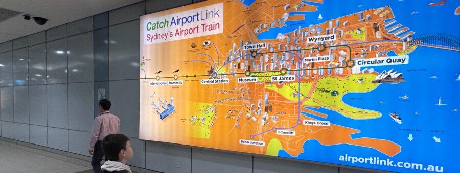
Most recently, I took my young son and wife to the spectacular city of Sydney, and we explored quite a bit of it including regional destinations like the Blue Mountains and Manly using a mixture of trains, trams, buses and ferries. Not having been to Sydney for some years, I was amazed and delighted to learn that they re-introduced the tram on George Street after more than 60 years connecting Circular Quay with Central Station. I was delighted that Sydney has been making great efforts to improve its public transport, although I am in total disagreement with the outrageous toll charges for road users, but that’s for another story. Sydney seamlessly integrates all their ferries, trams, and trains in easy-to-read diagrammatic format. I have to say the ferries are simply enchanting and so-much loved by those who use them.
I don’t think my son has quite the same obsessive interest with maps as I do, however, I was quite impressed with the ease it is to travel around Sydney. Even a young child can understand with not much difficulty how to get around it. However, it all centres back on one thing. The introduction of diagrammatic maps for metro train networks, which our friend, Harry Beck, introduced to the world way back in 1931.
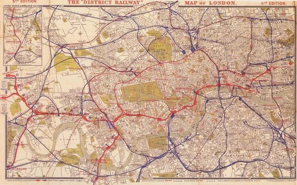 Old London Metro before diagrammatic maps were introduced
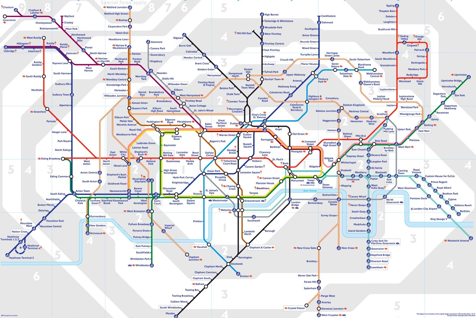
Modern-day map of the London Underground
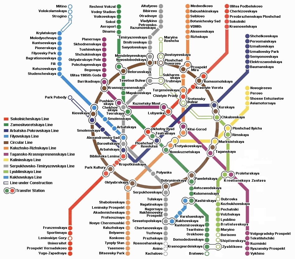
Moscow’s Underground Metro Map
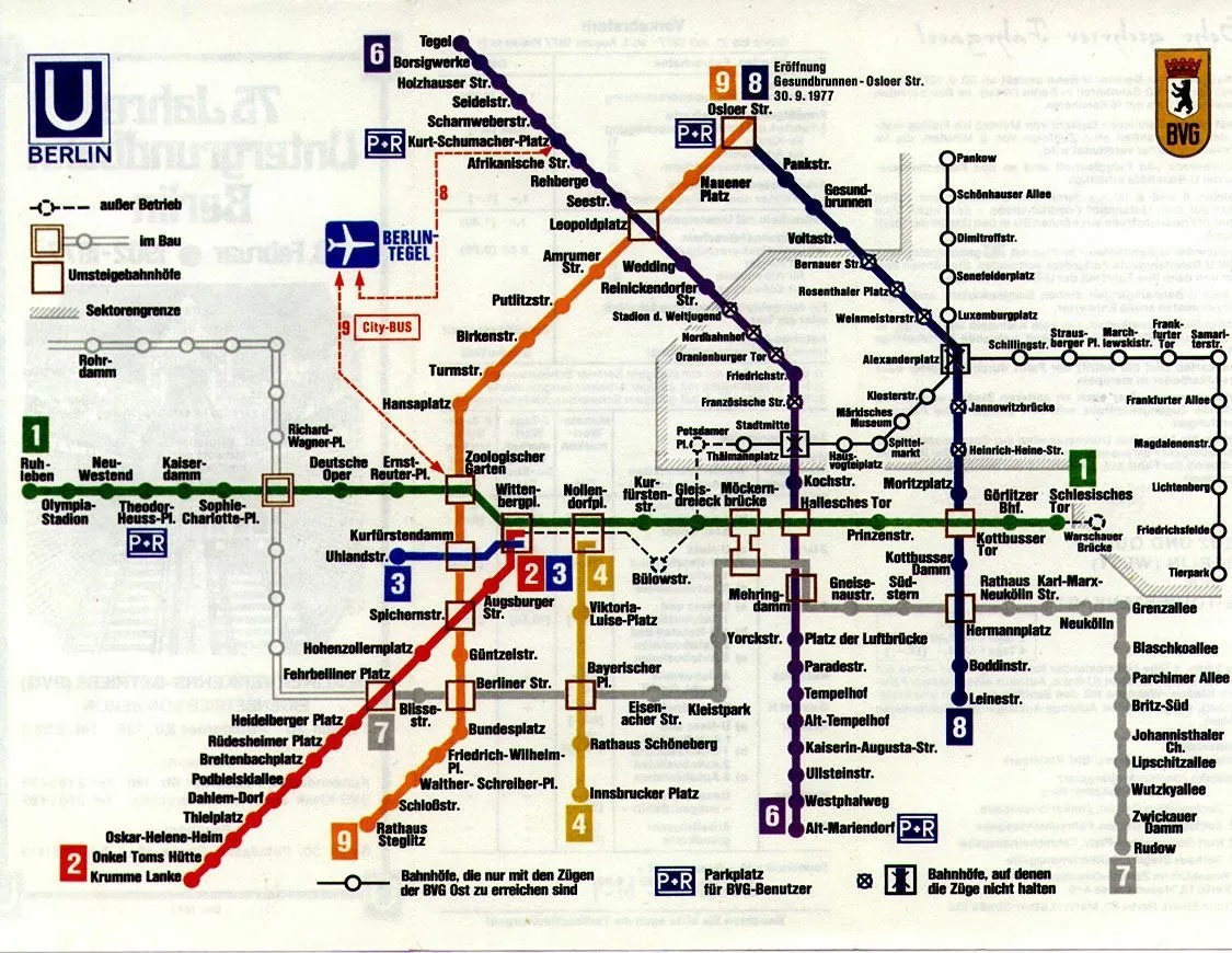
Berlin U-Bahn map from 1977. Note the grey Iron Curtain and closed stations